|
|
MAP IT: GPS/GIS
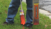
 As an extension of One Call Concepts Locating Services, our team employs GPS and GIS technology to offer PointPositive utility mapping services. Developers, institutions, municipalities and utility owners have reduced their costs, enhanced their information flows, and saved many thousands of dollars in damages to underground utility lines by employing PointPositive's accurate, state-of-the-art utility mapping and GIS services.
PointPositive's services are geared toward preventing service disruptions, reducing damages to your facilities, improving planning and development, eliminating costly repairs, and facilitating informed business decisions through the use of and access to accurate, reliable infrastructure information.
PointPositive has a dedicated and experienced workforce with extensive underground locating and utility infrastructure knowledge and expertise. We blend consulting services with accurate mapping resources to create, manage and track your critical data.
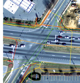
PointPositive Utility Mapping & GIS was created to support the increasing demand for more accurate and comprehensive information. In today's data-driven society, facility owners and engineers can no longer afford to work with outdated records and incomplete paper maps. They need access to fast, reliable utility information for planning, maintaining, repairing, protecting and tracking facilities.

PointPositive brings a full-service utility mapping and GIS solution that includes:
PointPositive maps, locates, and identifies:
PointPositive is for:
PointPositive uniquely blends professional locating expertise with sophisticated mapping technology specifically for managing utilities. We offer a practical and economical approach to help you meet your goals based on our specific subject matter knowledge and extensive experience in the utility locating and mapping environment.
Work with knowledge.
Plan with efficiency.
Maintain accurate records.
Protect infrastructure assets.
Dig with confidence.